Illegal dumping is becoming a huge environmental problem with severe consequences for ecosystems, water quality, public health, and the general population’s well-being. Traditional monitoring methods, such as on-site inspections or reports from the citizens, are labor-intensive, extremely slow, costly, and most importantly highly limited in scope. In some countries, the illegal disposal of waste and dumping constitutes a huge problem.
The increasing availability of high-resolution satellite imagery presents an excellent opportunity to efficiently monitor large areas for dumping detection. However, manual analysis of these images is extremely time-consuming, given the vast number of images that must be examined to cover even the smallest municipalities. Thus, this challenge highlights the need for solely automated solutions. Inspired by this challenge, we developed an AI model capable of detecting illegal dumping from satellite imagery, enabling us to bridge the gap between efficient environmental monitoring and scalable, data-driven automated solutions.
Beyond efficiency and low cost, early detection is critical for law enforcement and environmental hazard mitigation. Dumping sites can lead to long-term soil contamination, water pollution, and serious threats to wildlife. An AI-driven approach enables environmental agencies and policymakers to prioritize intervention actions, respond promptly to illegal dumping activities and make informed decisions based on concrete facts and analytics. Therefore, the motivations for this solution are to harness the power of modern AI to reduce environmental damage and to empower stakeholders with actionable insights.
Applying dumping detection to satellite imagery constitutes an interesting AI-related problem, a domain in which computer vision techniques and deep learning models thrive. Thus, we apply modern deep learning architectures whose input consists of high-resolution satellite images acquired through an automated pipeline comprising software that, given an area of interest, carries out the entire procedure autonomously. The images are processed to produce an output segmentation mask depicting the presence of dumping in each input image. More than 30,000 images have been collected and used for training our deep learning model, depicting real occurrences of dumping and waste from satellite images of various spatial resolution, from all around the world. Thus, our AI model was trained based on real-world dumping incidents from multiple years with manual and semi-automatic annotations. When performing inference on images acquired from different satellite sensors, under varying weather conditions, or from regions with topographic differences, performance degradation can occur due to data distribution shifts. To mitigate this issue, we employ a proprietary domain adaptation method that significantly improves the model’s robustness to small-to-moderate distribution shifts.
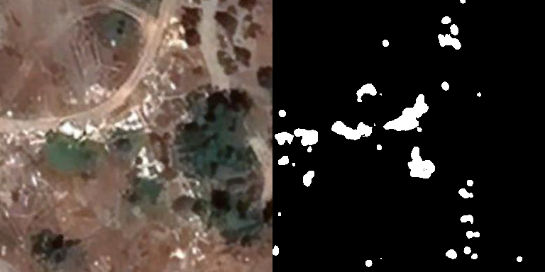
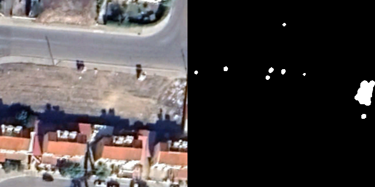
We tested the model across diverse terrains and landscapes via a diligent evaluation process. Some images of the results are listed below, with the original image on the left and the mask detected via our AI model on the right:
The model achieves a precision of 85% and a recall of 90%. Concretely, this means that only 10% of the actual (ground-truth) dumping area is not flagged as dumping and 15% of the flagged area is not actually dumping. We have to note that the results refer to dumping area detection, not dumping site detection. This suggests that dumping sites may be detected by the model, but their size may sometimes be over- or under-estimated. In fact, the recall and precision of detecting whether any dumping is found in an image, ignoring the accuracy of its size estimation, are 96% and 92%, respectively.
Overall, these results indicate that the proposed approach is highly effective at identifying illegal dumping across heterogeneous environments, while maintaining a reasonable trade-off between missed detections and false alarms. The higher recall and precision achieved at the image level further demonstrate the model’s suitability as a large-scale screening tool, where reliably flagging images that contain any dumping is more critical than precisely estimating the extent of each dumping site. In practical deployments, this enables efficient prioritization of areas for further inspection or downstream analysis, while tolerating minor inaccuracies in area estimation that can be refined through post-processing or human review. Most importantly, the results suggest that dumping detection can be conducted cost-effectively and at a large scale, enabling widespread monitoring and timely intervention in areas prone to illegal waste disposal.
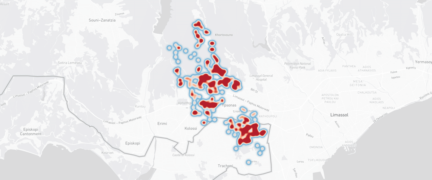
The importance of automated dumping detection extends beyond environmental preservation. It constitutes a step toward sustainable urban and rural management, helping communities maintain cleaner and healthier living spaces. By applying large-scale monitoring, AI can identify not only active dumping sites but also dumping trends, patterns, and hotspots, offering deeper insights into the behaviors and practices behind illegal dumping. An example of a hotspot created after few months of observation at a municipality of Cyprus is the one below:
These insights can shape policy changes, new regulations, public awareness campaigns, and targeted interventions that ultimately reduce the frequency and impact of such activities.
Moreover, this technology exemplifies the potential of satellite imagery and AI to address complex societal challenges. It serves as a model for leveraging data-driven approaches in environmental protection, disaster management, and resource planning. By transforming raw satellite images into actionable intelligence, stakeholders are empowered to act proactively rather than reactively, helping mitigate a serious global problem. This shift from reactive monitoring to predictive oversight could reshape how communities and governments approach ecological responsibility on a global scale.
Looking forward, the development of AI models for satellite-based dumping detection opens avenues for broader environmental monitoring applications. The same methodologies could be adapted to monitor deforestation, monitor illegal mining, detect oil spills, or assess the impact of natural disasters. Integrating this model with other data sources, such as drones, IoT sensors, or crowdsourced reports, could create a multi-layered environmental intelligence system capable of delivering real-time insights across diverse geographic and ecological contexts.
From a societal perspective, adopting such technologies fosters a culture of accountability and proactive stewardship. By making illegal activities visible and measurable, AI not only aids enforcement but also encourages sustainable practices among communities and industries. Incorporating AI as an essential tool, facilitating and supporting moderators and policymakers in monitoring illegal and dangerous activities is crucial, given the challenges modern societies increasingly face nowadays.